A map is a promise. When you trace your finger over a thick blue line representing a river or a jagged grey one marking a mountain range, you are looking at reality. But the most powerful lines on any map are the ones you cannot see. They are the administrative boundaries, the invisible walls that dictate where a school can be built, who pays which tax, and where a massive urban dream begins or ends.
In the quiet halls of Hong Kong’s government offices, these invisible lines are currently being redrawn.
Secretary for Development Bernadette Linn recently stood before the Legislative Council to clarify a point that sounds like dry bureaucracy but carries the weight of a city’s future. She confirmed that any changes to the boundaries of the Northern Metropolis—a gargantuan development project intended to house millions and anchor the city’s tech ambitions—will require the formal nod of the legislature.
It sounds like a procedural hiccup. It is actually a battle for the soul of the city’s northern frontier.
The Farmer and the Frontier
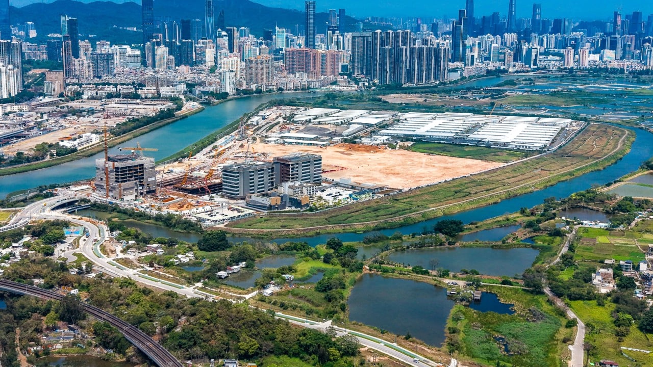
Consider a man named Mr. Chan. He has farmed a small patch of land near the Shenzhen River for forty years. To him, the "Northern Metropolis" is not a glossy brochure or a set of GDP projections. It is the sound of heavy machinery getting closer every month. For years, the boundary of what was considered "the border zone" remained static. It was a place of wild grass and rusted fences.
Now, the line is moving.
When the government decides to shift a boundary by a few hundred meters to accommodate a new high-tech hub or a highway interchange, Mr. Chan’s world shifts with it. Suddenly, his land is no longer "rural." It is "strategic." The value of the dirt beneath his fingernails changes overnight. This is why the news from the Development Bureau matters. If the government could move these lines with a simple stroke of a pen in a private office, the public would be left chasing ghosts.
By requiring Legislative Council (LegCo) approval for boundary shifts, the city is effectively saying: We will not move the goalposts in the dark.
The Calculus of Space
Hong Kong has always been a city defined by its constraints. We are a vertical miracle carved into the side of emerald hills. But the Northern Metropolis represents a departure from that verticality. It is a horizontal expansion, a stretching of the city’s limbs toward mainland China.
The project covers roughly 30,000 hectares. Within that space, the government aims to create a "San Tin Technolegy City," a hub for innovation that is supposed to rival Silicon Valley. But innovation requires more than just fiber-optic cables and glass towers. It requires land. Lots of it.
During the recent discussions, lawmakers raised a vital concern. If the project is so massive, and the timelines so long, how do we stop the boundaries from "creeping" without oversight?
Linn’s response was a calculated exercise in transparency. She noted that while the government needs flexibility to adapt to changing economic winds, the fundamental borders of the development areas are locked into statutory plans. You can't just wake up on a Tuesday and decide the Metropolis is now ten percent larger because a developer asked nicely.
Changing those lines involves a dance. First, the Town Planning Board must weigh in. Then, the public gets a chance to shout, cheer, or complain. Finally, it lands on the desks of the legislators.
Why the Red Tape is Actually Green
We often complain about the slow pace of government. We want things done yesterday. We want the housing crisis solved, the tech jobs created, and the economy bolstered. But in the context of the Northern Metropolis, "slow" is a safeguard.
Imagine if the boundary of a major development zone could be altered without a public vote. A park could be swallowed by a parking lot. A heritage site could be "accidentally" included in a high-density residential zone. The requirement for LegCo approval acts as a friction point—a necessary heat shield that prevents the machinery of development from burning through the interests of the people living on the ground.
The stakes are not just financial. They are environmental. The northern New Territories are home to fragile wetlands and migratory bird paths that have existed long before the first skyscraper touched the Hong Kong clouds. When we talk about "boundary changes," we are often talking about how close the concrete gets to the mud.
The Ghost of the "Checklist"
There is a temptation to view this news as a checklist item.
- Boundary change? Check.
- LegCo approval? Check.
- Minister statement? Check.
But look closer at the friction between the lawmakers and the Development Bureau. Some legislators expressed worry that the current definitions are too vague. They asked: What constitutes a "major" change? If you move a line by ten meters, do you need a full debate?
Linn’s stance remains firm: the existing system of Gazettal—the official publication of government decisions—and the statutory planning process provide enough sunlight. It is a delicate balance. Too much oversight and the project dies in a graveyard of committee meetings. Too little, and the public loses trust.
Trust is the most expensive commodity in Hong Kong right now.
A City Within a City
The Northern Metropolis is not just an extension of the current city; it is an attempt to build a second heart. For decades, Hong Kong has been lopsided. The wealth, the jobs, and the power were concentrated around Victoria Harbour. The North was the "backyard."
The shift of the boundary lines is the physical manifestation of a psychological shift. We are no longer looking out toward the sea as our only lifeline. We are looking across the river.
This brings us back to the invisible lines. When a minister says that LegCo must approve a boundary change, they are acknowledging that the Northern Metropolis belongs to the people, not just the planners. It is a reminder that even in a city of high-speed rail and 5G networks, the most important technology we have is the law.
The Weight of the Pen
The next time you see a map of the New Territories, don't just look at the roads. Look at the faint, dashed lines that separate one district from another. Think of the hours of debate, the stacks of environmental impact reports, and the heated arguments in the Legislative Council chambers that went into placing that line exactly where it is.
These lines determine where a young couple can afford their first flat. They determine if a startup can afford its first office. They determine if a crane will eventually swing over Mr. Chan’s farm.
The minister’s promise of legislative oversight is a promise of accountability. It ensures that as the city grows, it does so with its eyes open. The Northern Metropolis is a giant, and giants must be guided carefully.
The ink is drying on the new maps, but the pens are still held by many hands.
The map is a promise. And for once, the process is making sure it is a promise the city can actually keep.